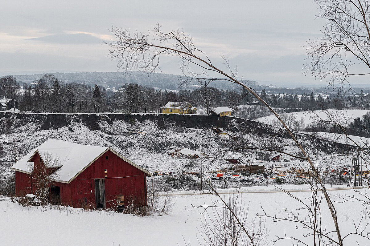




Quick clay is a silent threat beneath our feet. Found in many northern regions, this type of soil can suddenly lose its strength and collapse, triggering landslides that destroy homes, roads, and sometimes entire communities (Fig. 1). The 2020 quick clay landslide in Gjerdrum at Ask village took 11 lives and (Fig. 1 Top) displaced more than 1600 people with huge destruction of the properties; in 2024 in Levanger, during road construction, a landslide killed 1 person and luckily there were no houses around.
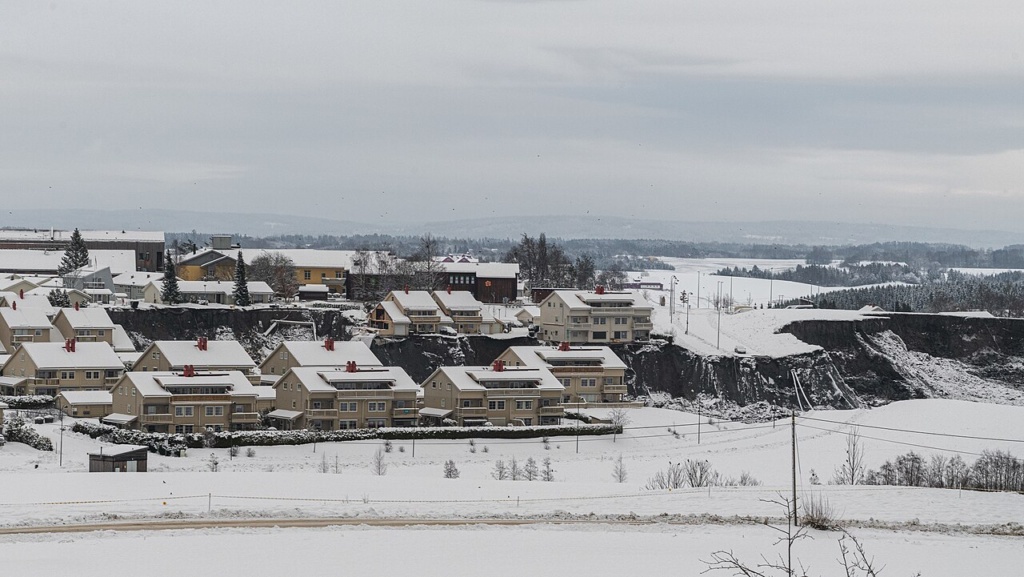
The devastation effect of recent quick clay slides in Norway caught our attention. As experts on subsurface especially on shale/clay, we were wondering how we can contribute to a deeper understanding of quick clay behaviour under both stable and destabilizing conditions. Such understanding is essential for improving knowledge on failure mechanisms and for developing effective strategies for prevention, protection, risk assessment, and monitoring.
Research challenges
Over the past decades, extensive research has been conducted, especially in countries where quick clay is found (across the Northern Hemisphere) and has brought devastation to the society. Despite significant advances, many uncertainties remain regarding the complex interactions between geological, hydrological, and mechanical processes that govern quick clay stability and failure.
Because quick clay is a geographically restricted phenomenon, research efforts have largely been concentrated in affected regions rather than being pursued globally. Consequently, there remains considerable scope for further interdisciplinary research aimed at enhancing predictive capabilities, improving monitoring technologies, and strengthening mitigation measures to reduce the societal and economic impacts of quick clay landslides.
What is Quick Clay
Quick clay, also known as highly sensitive clay, was deposited in marine environments under saline conditions following the last glaciation, approximately 11000 years ago. During this period, large areas of northern Europe and North America were submerged beneath seawater, allowing fine-grained sediments to accumulate in coastal and fjord settings. As the continental ice sheets melted, the removal of the immense ice load triggered post-glacial rebound, causing formerly submerged land areas to gradually rise above sea level. Unlike many sedimentary deposits that become stronger through burial and diagenetic processes, quick clay experienced relatively rapid uplift and limited subsequent sediment loading. As a result, these clay deposits remained soft, weakly consolidated, and largely uncemented, making them susceptible to instability under certain conditions.
The unique sensitivity of quick clay is closely linked to its geochemical history. In the original marine environment, dissolved salts in seawater helped stabilize the clay particle framework by reducing electrostatic repulsion between particles.
Following uplift, however, groundwater infiltration and precipitation gradually leached these salts from the sediment. Although the clay structure often retained its original arrangement, the loss of saline pore water significantly weakened the interparticle bonds. This process created a metastable soil fabric that can remain intact under undisturbed conditions but may collapse rapidly when disturbed, resulting in a dramatic reduction in shear strength and, in some cases, catastrophic landslide failure.
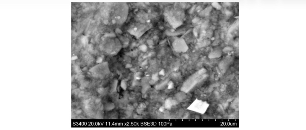
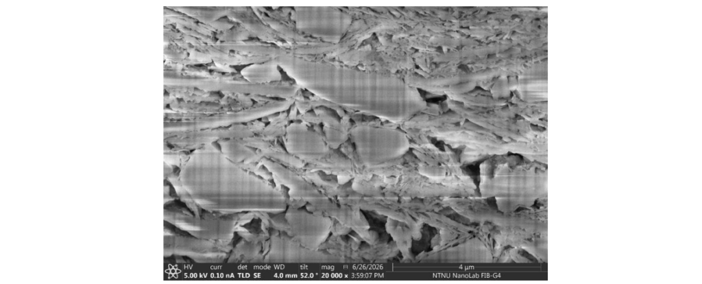
Understanding the interplay between post-glacial geological evolution, soil structure, and geochemical alteration is therefore crucial for assessing the behaviour of quick clay deposits and developing effective approaches for hazard identification, monitoring, and risk mitigation. A closer look at the quick clay can be seen in Figure 2 and 3.
Prediction of landslide
Quick clay deposits can be detected using geophysical measurement methods, primarily by combining electrical resistance measurements with seismic. Reliable mapping also involves drilling core samples that can be characterized by geotechnical parameters such as shear strength and porosity, as well as identification of various clay minerals using X-ray diffraction and the salt content of the pore water.
But even if we know where the quick clay is, we cannot know if and when it will collapse: In its original state, it is solid and load bearing, but when it is activated, it transforms into a liquid phase. This “phase transition” is triggered by various external influences, partly natural, such as when prolonged and/or heavy rainfall reduces the binding salt content, or by human influences in the form of loads or changes in the landscape that affect mechanical stresses and pore pressure in the subsoil.
In order to predict a natural disaster such as a quick clay slide, it is necessary to understand the mechanisms that lead to collapse and which measurable parameters change in advance, and which can thus provide a warning of the coming disaster. An important point is how long the development of collapse takes. This is quite unknown and will vary from case to case, but there is a reason to believe that the collapse mechanism is a controlling factor.
Quick clay slides have parallels to, for example, earthquakes or volcanic eruptions: Exact prediction of time and place is in practice impossible, but monitoring changes in the speed of seismic waves or incipient seismicity can help to provide warning. Combined with geomechanical modelling, which assumes that a realistic earth model has been established in advance, perhaps it may be possible to predict a probable earthquake or quick clay landslide in the future.
Why applied geoscience department of SINTEF is interested
At SINTEF, we have been working for several decades on similar issues related to changes in the bedrock during oil and gas production or to the injection of fluids, be it water or CO2, for increased recovery and storage, respectively. Clay-rich formations (“shale”) have been and still are on our research focus for decades for various application e.g. for borehole stability, plugging and abandonment of wells etc. Chalk (which is the reservoir rock in several fields in the North Sea) can become liquid during production (“liquefaction”) and weak sandstones can lead to mass production of sand into a gas or oil-producing well.
At SINTEF we perform fracture mechanics experiments with all these rocks and map how, among other things, sound speeds change during collapse. We can also record acoustic emission or “earthquakes” on the millimetre scale from the samples. The laboratory observations are linked to analytical rock physics models that are used in large-scale numerical geomechanical models.
Our mission
This study has two primary objectives: (1) to identify reliable methods for monitoring quick clay deformation prior to failure and improving failure forecasting, and (2) to develop or adapt laboratory characterization techniques that can be directly linked to and support field-scale monitoring.
Our ambition in the work with quick clays is to find out, in collaboration with geotechnicians and others with relevant experience, to what extent the knowledge from the petroleum industry is transferable to this problem.
Initially, we asked the question of whether it is possible to predict quick clay landslides. An encouragement on the way can be found in the work of Mainsant et al, who in 2012 published an observation of a reduction in shear wave velocity from 360 to 200 m/s in situ in quick clay several days before a landslide occurred. Of course, they monitored an area where they knew that landslides could occur, but the fact that the weakening of the clay could be detected before the actual landslide suggests that the answer to the question is: Yes, maybe.
To reduce the uncertainty in this answer, we will study mechanisms for activation using small-scale experiments and pore-scale imaging. An important part of this is the measurement of attributes that can provide indications of increasing landslide risk. Examples are shear wave velocity, pore pressure and time scale for changes in these parameters. The structure of quick clay is sometimes described as a “house of cards”, meaning essentially an open structure of unbonded particles. The structure remains intact as long as all particles maintain their positions, however even a small disturbance can make the whole structure collapse. Modelling an intact quick clay structure is difficult, because its stability is a singularity surrounded by extreme instability for any modification of the structure.
To visualize deformation and fluid-front propagation, we use Saltwash South sandstone, a well-characterized sandstone from Utah, USA. Unlike clay, its larger grains are visible in µCT scans. When saturated with water or NaCl brine, the sandstone can lose all cohesion and disintegrate into loose sand, whereas it remains intact when dry or saturated with KCl brine.
This behaviour, caused by clay-rich cement between quartz grains, resembles quick clay liquefaction. Saltwash South sandstone presents an ideal material for studying rock decohesion due to its high permeability and relatively large pore sizes. These properties provide observation of fluid-driven weakening processes using X-ray CT imaging and conventional photography. Decohesion appears to be governed by two propagating fronts: a fluid saturation front and a deformation front. By tracking these fronts in image sequences, we aim to quantify their velocities and relate them to rock properties such as porosity, permeability, grain characteristics, and clay content. Because the process involves fluid infiltration and the swelling or dissolution of clay-rich cement, it may offer insights into the mechanisms that trigger quick clay liquefaction, albeit at a much finer scale and with different clay compositions.
Ultimately, these experiments could help develop improved mechanical models of liquefaction onset and inform monitoring strategies that provide earlier warnings of landslide hazards. Perhaps knowledge gained from these experiments will translate to quick clay or at least inspire us to propose a rock mechanical model of the liquefaction onset. From there, the hope is to be better equipped to suggest useful monitoring methods, giving a sufficiently early warning of impending landslide.






Comments
No comments yet. Be the first to comment!