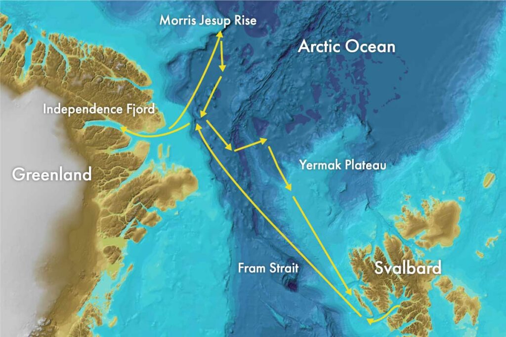

This expedition’s destination is Morris Jesup Rise, an underwater feature jutting out northwards from the northern part of the Greenland shelf. The main focus this time will be on geology and geophysics, but the team onboard is multidisciplinary and working on behalf of remarkably varied projects.
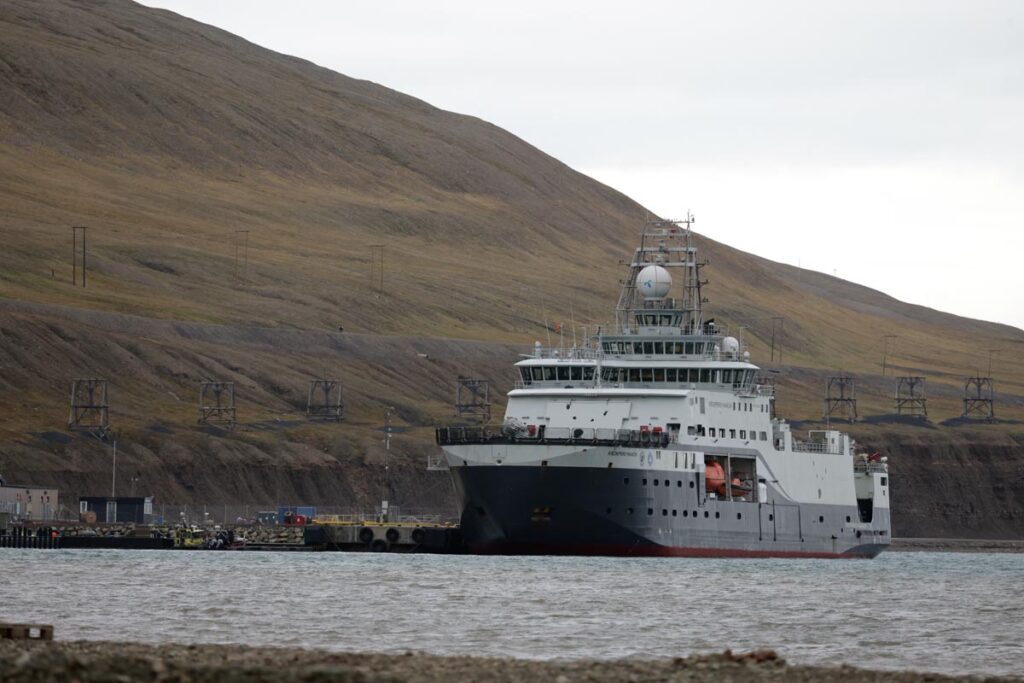
This year’s expedition is also a unique collaboration between Norwegian research vessel RV Kronprins Haakon and its Swedish counterpart Oden. The two ships are expected to meet off the coast of northern Greenland.
At the time of publishing, Kronprins Haakon is being loaded with the tonnes of equipment necessary to collect the required samples and data. As soon as that process is completed, the ship will set out towards its first research objectives, outside the mouth of Svalbard’s Isfjord.
Geophysics and geology
A common denominator of Arctic Ocean research, particularly when it pertains to the sea floor and what lies beneath, is that there is comparatively little data available. This is due to the fact that sea ice has made – and still makes – gathering samples and data much more difficult than in other areas of the world.
This scarcity of data makes each new discovery all the more exciting, as it expands our knowledge of a poorly understood area.
The Eurasian Basin and the Fram Strait
The Eurasian Basin is an area of deep ocean situated between the Svalbard archipelago and the North Pole. The forces moving our planet’s continents began forming that deep ocean basin about 53 million years ago. At that time, the Arctic Ocean was more isolated than it is today, with limited water exchange with the world’s oceans. Then, the Fram Strait, a deep channel which connects the Arctic and Atlantic Oceans, opened up between Greenland and Svalbard.
Our knowledge of how and why these events happened, and of their consequences, is fragmented. By gathering geophysical data through seismic profiles, and by looking at the sediments that have been gathering at the bottom of the sea since these events occurred, scientists hope to answer critical questions about the area’s history.
When the shape of an ocean basin and its connections to the rest of the world change, this has dramatic implications: ocean currents reorganise; temperature, salinity and the atmosphere are all impacted, as well as the climate and life itself. Looking at the history of these changes, and learning more about warmer periods of the past, may help us understand what is in store for us as the Arctic region undergoes rapid warming.
What will a “blue Arctic” be like?
No one knows exactly when the Arctic Ocean will be entirely free of ice in the summer, but the scientific consensus is that this will happen before the end of this century.The earth has had warm, greenhouse climates before. By examining what the sediment layers tell us about the conditions at that time, we can better understand what an ice-free Arctic Ocean will mean for humanity.
The Intergovernmental Panel on Climate Change’s Sixth Assessment Report expects the Arctic Ocean’s first ice-free year to occur between 2040 and 2072.
The plan is to collect sediment samples from key locations: Morris Jesup Rise and the Yermak Plateau. Sediments at Morris Jesup Rise contain information about sea ice transport out of the Arctic Ocean, while those at the Yermak Plateau are expected to shed light on the inflow of Atlantic water into the Arctic Ocean.
By collecting long sediment cores from both regions, scientists hope to be able to analyse sample material from two distinct periods affected by greenhouse warming – much like we are today. The data from these sediments will help validate scientists’ scenarios for what a blue Arctic Ocean might look like.
Microbes buried alive at the bottom of the sea
Did you know that 1% of the Earth’s biomass consists of microbes living in the sediment layers at the bottom of the sea? By comparison, humans account for just 0.01% of the total biomass. These microbes’ habitat extends to more than 1000 metres beneath the seafloor. Together, they control the fate of the world’s largest organic carbon pool.
The subseafloor organisms play an important role as gatekeepers of the interface between the subseafloor and the waters at the bottom of the ocean. Chemical elements, including organic carbon and other elements that are essential to life, are able to traverse that boundary through the actions of these microbes. In the Arctic Ocean, we know precious little about them. In fact, our knowledge of life in the deep subsurface sediments found in the central arctic ocean is based on 3 samples alone awith a combined volume of a few cubic centimetres.
Last year, samples were gathered during the 2023 GoNorth expedition, at a water depth of over 4000 metres. These clearly showed the presence of an active subseafloor microbial community that are slowly degrading the limited organic carbon buried along with them in the sediments.
During this year’s GoNorth expedition, scientists hope to expand our knowledge of the subseafloor biosphere and investigate the linkage between their activity and variability in past ocean circulation patterns and climate conditions.
Climate change and fjords
Global warming seems to be changing the oxygen content of the world’s oceans. The changes are most profound in coastal and fjord settings, which has an impact on life in the fjords.
What we don’t know is how unprecedented these changes in oxygenation are, in a context of natural variability. Also unknown is how these oxygen changes impact biodiversity in the fjords. To answer these questions, scientists are going to gather sediment cores from the fjords. These cores are effectively working as a record of the past. Similarly, other cores gathered further out as sea should help get a better picture of past sea ice conditions.
The melting of the Greenland ice sheet
It’s no secret that the world’s biggest ice sheets, in Antarctica and Greenland, are melting. Some scientists think that large amounts of carbon are stored beneath. Other scientists dispute that hypothesis. But the truth is that no one knows. Getting a better estimate of how much carbon the ice sheets are storing is important, to know what impact their melting will have on the climate.
In addition to carbon, melting ice sheets release organic and inorganic matter, including nutrients and heavy metals. What effect will this have on the local ecosystems? What can the sediment record reveal about past effects of the ice sheets on ocean circulation and marine life? And what can that tell us about what the future has in store?
Through sampling water, plankton and sediment cores, scientists hope to get closer to answering all these questions.
Better ice maps through big data
Big data and machine learning are playing an increasingly central role in various sectors. Sea ice condition could become one of these sectors. Imagine icebreakers being equipped with an array of sensors gathering data, which is then automatically being processed to feed into better sea ice condition models.
To get there, we need to prototype sensor arrays, gather data, and see what the results look like. To this end, two PhD candidates on board will be collecting sea ice data with lidar, radar and camera systems.
About GoNorth
GoNorth’s objective is to push the boundaries of knowledge about Norway’s neighbourhood in the Arctic Ocean, from the sea floor and subsea geology, to the sea ice, via the water column. The project was launched in the wake of the 2009 decision by the UN’s Commission on the Limits of the Continental Shelf to grant Norways territorial claims on its northernmost shelf. GoNorth is led by NORCE.
GoNorth’s third expedition sets out 29 August, with a planned return on 19 September.


Comments
No comments yet. Be the first to comment!