
What Norway and New Zealand can learn from each other about climate resilience
Borrowing loosely from Dickens, this is a tale of two storms. Albeit, instead of 1700’s Paris and London and the French revolution, this is a modern story about Wellington and the small town Vassenden, and how extreme weather is an increasingly overwhelming aging infrastructure and threatening lives, homes and livelihoods.
As of 14 May 2026, New Zealand has experienced five major weather-related emergency events, resulting in 21 local or regional states of emergency. The impact on affected communities has been severe. Gaining insights from previous disasters is crucial for making well-informed decisions about managing climate hazards, exploring alternative strategies, and laying the groundwork for climate-resilient communities.
Two surprisingly similar countries
Having lived in both Wellington and Norway, I was vaguely aware the two countries had quite a lot of similarities in terms of nature and culture. However, earlier this year I looked a bit deeper and was quite surprised just how similar they are – at least in terms of population, geography and transport networks. Both countries are considered landslide prone, although New Zealand definitely has a bigger problem than Norway in this department, with nearly double the area with ‘steep’ slopes, weaker rocks and soils, and a generally wetter climate.
In my view, if Norway is to imagine a future with more extreme weather events and what kind of impacts this might have for an elongated, mountainous country with a geographically spread population, we only have to look at what New Zealand is experiencing now.
By looking beyond its own borders, Norway can avoid making some of the same mistakes, and also benefit from the lessons learned elsewhere, including positive examples of community-led initiatives that have strengthened local resilience.
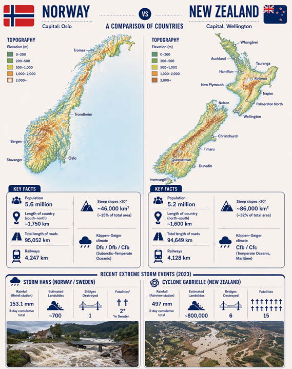
Figure 1 Infographic: Norway-New Zealand comparison. Credit: Made with AI by Erin Lindsay
A storm in Wellington
On Monday 19 April, the south of Wellington (where most of my family lives) was hammered by torrential rain from a localised thunderstorm. Between 3 and 4 am, 77 mm of rain fell within a single hour.
1 hour rainfall radar data. A MetService New Zealand Facebook post
This amount of water was far beyond the capacity of the neglected stormwater system. Surface runoff water swiftly turned streets into rivers, flood water flowed through houses, triggered landslides, then gathered in depressions in the terrain.
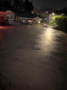
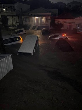
The lower end of Emerson Street in Berhampore (where my stepsister lived until two weeks before the storm). Credits: Bibi Hawkes, resident.
MetService New Zealand issued a Severe Thunderstorm Alert at around 4 am. One resident told of being woken by her phone vibrating off her bedside table and plopping into the flood water on her bedroom floor. Fire and Emergency New Zealand reported more than 150 weather-related callouts in Wellington that morning.
While most people managed to reach safety, the damage to property has been extensive. Tragically, one man was taken by a landslide that tore through the house he was in. In the first four months of 2026 alone, at least 11 people have died in New Zealand in flood- and landslide-related events.
Dr Thomas Robinson, Senior Lecturer in Disaster Risk and Resilience at the University of Canterbury, was quoted in an article by The Guardian saying that landslides “don’t stick in our psyche” the way earthquakes do. However, landslides have caused more than 1,800 deaths since written records began, more than earthquakes and volcanoes combined.
Given the events at the start of 2026 and other recent storms affecting both small communities and major cities, perceptions around landslides in New Zealand may begin to shift.
A storm at Vassenden
Like the storm in Wellington, a highly localized thunderstorm with exceptionally heavy rainfall occurred around Vassenden in Western Norway on July 30th, 2019. Data from private Netatmo weather stations indicated a peak hourly rainfall of 30 mm between 16:00 and 17:00, and a total of 83 mm over 24 hours. Observations from Meteorological Institute weather stations confirmed that multiple locations experienced more than 20 millimetres of rain within a single hour.
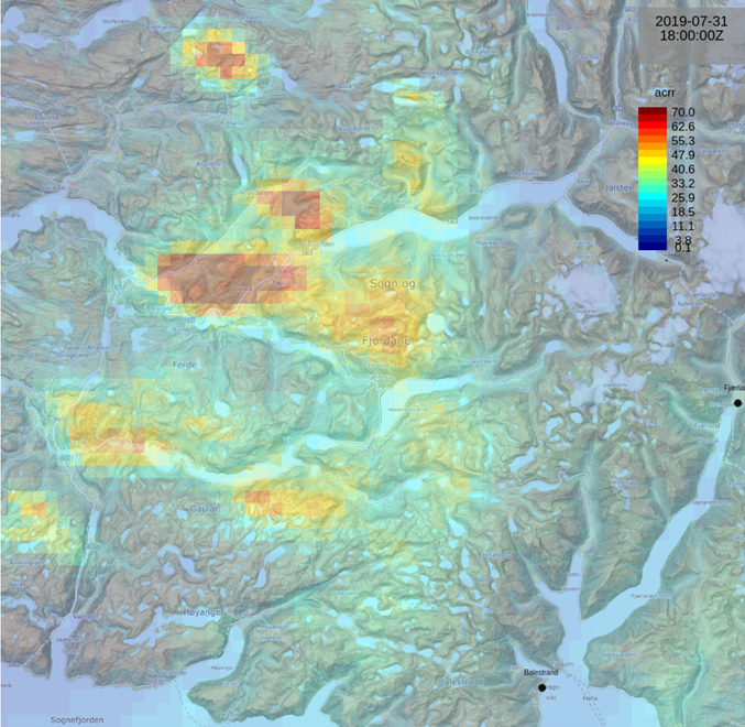
Radar image from Tuesday 30th July showing 6 hourly precipitations from MetInfo report. Credits: Norwegian Meteorological Institute
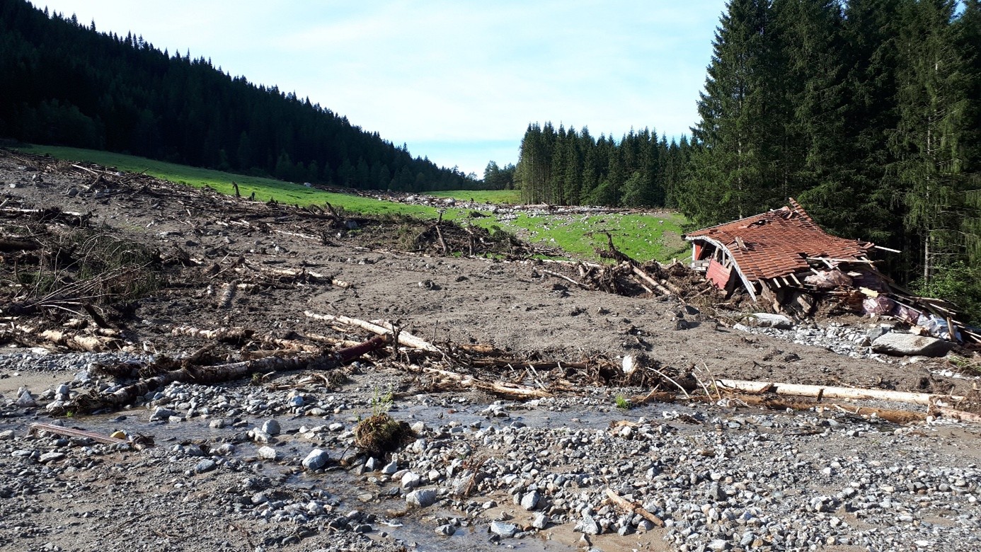
Although the rainfall was less than what Wellington experienced last Monday, the storm was nonetheless devastating for the local community. The town of Vassenden, situated in a valley between steep mountains, was completely isolated, with landslides and flood debris obstructing every road leading in and out of the town at 14 different points. Also tragically, a man lost his life when a landslide struck his car as he was evacuating the village.
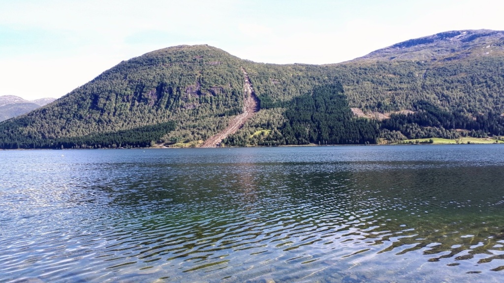
Large landslide on the southern side of Jølstravatnet lake. Credits: Erin Lindsay
Early warnings, hazard maps and mitigation measures
The science is not perfect.
In both cases, meteorologists had predicted heavy rain and issued warnings. But while forecasts can identify broad regional risk, localised thunderstorms are notoriously difficult to predict. Where exactly a high-intensity rainfall cell will form, and whether it will slow down or become anchored by hills or mountains, or pass by quickly, is much harder to predict. As a result, even when a regional warning is issued, the most severe impacts may still come as a surprise to those directly affected.
Landslide and flood hazard and susceptibility maps are also not perfect. At Vassenden, landslides started high on slopes where the landcover was mapped as ‘bare bedrock’, so showed no susceptibility, while in Wellington the street shown in the photos above was not previously mapped as flood prone.
In contrast to Wellington’s neglected storm water system, flood security measures in Vassenden completed two years prior to the storm likely helped prevent worse damages to homes and potential loss of life.
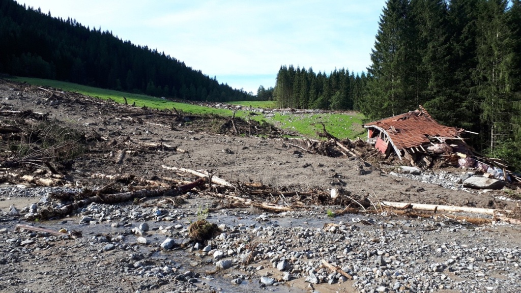
The Track of a Storm: Most buildings withstood the storm at Vassenden, with the exception of this wool shed in Slåtten. Credits: Erin Lindsay
Towards a climate resilient future
The lesson from these two storms is not that every landslide or flood can be predicted, prevented or mapped in advance. They cannot.
The lesson is that preparedness cannot rely on one tool alone.
Warnings matter, but warnings need to reach the right people in time. Hazard maps matter, but maps need to be updated when events reveal blind spots. Mitigation measures matter, but they need long-term investment and maintenance. Local knowledge matters, because residents and infrastructure managers often know where water gathers, where slopes are unstable, and which roads become dangerous first. Insurance data matters, because we need to understand economic and social consequences to prioritise investment in mitigation measures. And technology matters, because satellites, sensors, weather radar and infrastructure monitoring can help us see what is happening over large areas, especially when access on the ground is impossible.
This is where Norway and New Zealand have much to offer each other. Norway has strong national systems for hazard mapping, warning services and infrastructure management. New Zealand has hard-earned experience from repeated extreme weather events, including the role of communities, local response and recovery after disasters. Both countries have steep terrain, scattered settlements, vulnerable transport corridors and ageing infrastructure exposed to a changing climate.
Climate resilience is not only about building higher walls, larger culverts or better models. It is about building systems that learn. After every storm, we should be asking: What did we know beforehand? Who received the information? Who acted on it? What failed? What worked? What surprised us? And how do we make sure that knowledge is not lost before the next event?
Viva la revolución!
A tale of two storms is therefore also a tale of two opportunities. Norway does not need to wait for the same scale of disasters before strengthening preparedness. By looking outward – to New Zealand and to other countries already facing repeated climate-driven disruptions – we can learn faster, test new approaches, and avoid some mistakes before they are repeated.
The future will bring more intense rainfall, more pressure on infrastructure, and more situations where local events have wider consequences. But it also brings an opportunity to rethink how we share information, how we connect national expertise with local experience, and how we prepare communities before the next storm arrives.
In that sense, the comparison between Wellington and Vassenden is not just a story about damage. It is a story about learning, and about the kind of climate resilience we now need to build.


Comments
Thank you Erin a great comparison and useful detail. I live in Wellington and was lucky – this time.