CO2Datashare releases curated datasets from the Illinois Basin – Decatur Project
Over a period of three years, approximately one million tons of CO2, captured from the ethanol production plant at the Archer Daniels Midland (ADM) facility in Decatur, Illinois, USA, was injected into the Mount Simon Sandstone, more than two km deep in the Illinois Basin. These demonstration projects are essential for gaining an understanding of the workflows and monitoring equipment needed to be able to geologically store CO2 at a commercial scale, and for gaining public confidence in the technology.

The Illinois Basin – Decatur Project
The Illinois Basin – Decatur Project (IBDP) (2007-2021) was carried out by the Midwest Geological Sequestration Consortium, one of seven USDOE NETL Regional Carbon Sequestration Partnerships that were formed to evaluate the safety and effectiveness of CO2 geological storage as a mitigation tool to address global climate change. The Illinois State Geological Survey at the University of Illinois was the principal investigator for and manager of the IBDP, with the Indiana Geological Survey (now the Indiana Geological and Water Survey) and the Kentucky Geological Survey as key partners. Many other organizations and individuals contributed to the success of the project, including ADM, Trimeric Corporation, and Schlumberger. The aim of IBDP was to demonstrate safe and effective storage through the injection of one million tons of CO2, captured from the corn processing plant for fuel ethanol production at the ADM facility in Decatur, Illinois USA.
The storage complex at Decatur includes the Mount Simon Sandstone, the lower third of which contains fluvial deposits with excellent reservoir quality. The Mount Simon Sandstone is overlain by low permeability shales and mudstones of the Eau Claire Formation, which serves as a caprock/seal for the reservoir.

IBDP datasets have been released
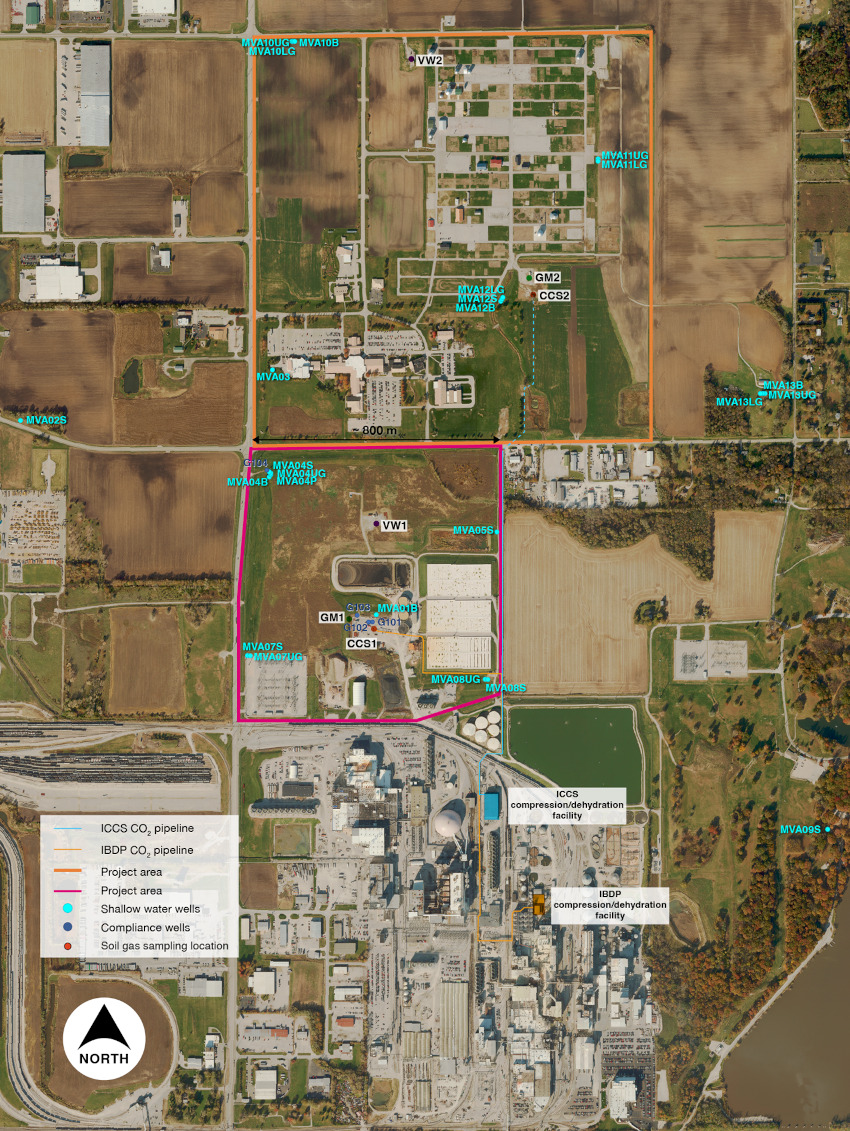
The datasets that have been released contain information from the IBDP workflow, from pre-injection site characterization (2007-2011), to injection and monitoring (2011-2014), and post-injection (2014-2021). The infrastructure installed for the IBDP includes three deep wells: injection (CCS1), monitoring (VW1), and geophysical (GM1). It also includes 17 shallow groundwater monitoring wells, microseismical monitoring with down-hole, four-component sensors in the injection well, an in-well geophysical monitoring array for repeat plume monitoring using vertical seismic profile (VSP) methods, a compression/dehydration facility, and a 1.9 km pipeline.
The released datasets include:
- GIS and Georeferenced Imagery: provides a GIS-based portrayal and spatial archive of the IBDP project wells, and the distribution of near-surface monitoring and sampling installations that were present at the IBDP field site.
- Seismic data: includes IBDP 3D seismic (volume reprocessed), IMDP 3D time-lapse VSP (vertical seismic profile) (reprocessed), and IBDP passive seismic events monitoring (micro seismic).
- Well information: includes data collected from the three deep wells drilled in the project, such as geophysical logs, core and sidewall core analyses, and various well tests. It also includes stratigraphic tops picked from the project wells and representative geologic cross-sections, as well as well design summary sheets and directional surveys.
- Horizons and Faults: exported from the Petrel geological model.
- IBDP geological model: features a Petrel model containing wells, horizons, and fault interpretations from the project.
- Technical reports: includes geo-mechanical reports, site map images, static model reports, stratigraphy, well completion reports, well diagrams, well testing reports and the final report. In addition, several selected reports and outreach material have been made available.
Please note, the full IBDP datasets are currently available on the U.S. Department of Energy’s EDX system. Due to the large size of the microseismic data set, CO2Datashare offers a curated sub-set of this data detailing located microseismic events.
CO2DataShare
The sub-set of the IBDP data and more information about the data can be found in the CO2DataShare portal where the final report from the project can also be found:
Sallie E. Greenberg, Ph.D: ILLINOIS BASIN—DECATUR PROJECT Final Report: An Assessment of Geologic Carbon Sequestration Options in the Illinois Basin: Phase III. Illinois State Geological Survey. July 2021.
CO₂DataShare, a platform for sharing CO₂ storage data, was launched in 2020. The portal builds on UNINETT Sigma2’s solution for data storage, combined with a tailored frontend that is developed using the open-source software CKAN. The project is a collaboration between SINTEF, the University of Illinois, Equinor og IEAGHG with financial support from CLIMIT and the US Department of Energy. It is coordinated with the Norwegian CCS Research Centre (NCCS).
More information about CO2DataShare can be found on the project web page.


Comments
No comments yet. Be the first to comment!