Over the course of the last few months, we have been working with experts from around the world, each of whom are providing components and brand-new solutions to the OceanLab Observatory, which will be established in Trondheimsfjord this year. Our goal with the Observatory is to support projects that help understand the marine environment and to test new technology that will help the rest of the world do the same. The Observatory is one of five parts to the OceanLab National Research Infrastructure that is being built now in collaboration with NTNU, and funded by the Norwegian Research Council. In-all, OceanLab will provide state-of-the-art field facilities for subsea robotics, autonomous shipping, aquaculture, marine observation, and digitalisation. This will provide exciting new possibilities for ocean research nationally and internationally – it is the first step in developments of the full-scale field lab of Ocean Space Centre (Fjordlab).
In this first phase of developments, the Observatory will consist of two data buoys and a suite of ‘mobile sensors’ that can be used on fieldwork. We plan to set out the two buoys in the fjord in August-September (2021). One will be positioned near Ingdalen (west of Trondheim), and one will be near the Munkholmen island, close to the city.
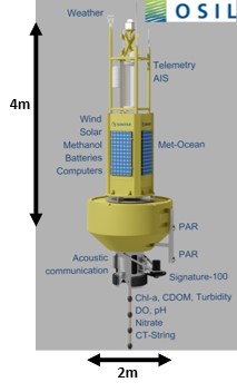
The databuoy to be deployed near Ingdalen and has been carefully constructed to be tightly packaged with a large number of environmental sensors, covering parameters such as: water hydrodynamics, biomass, nitrate, pH, oxygen, weather, waves, and more. This system is provided by OSIL (UK), who have worked hard to find ways to package all of these sensors into a small space that can withstand all seasons and all weather.
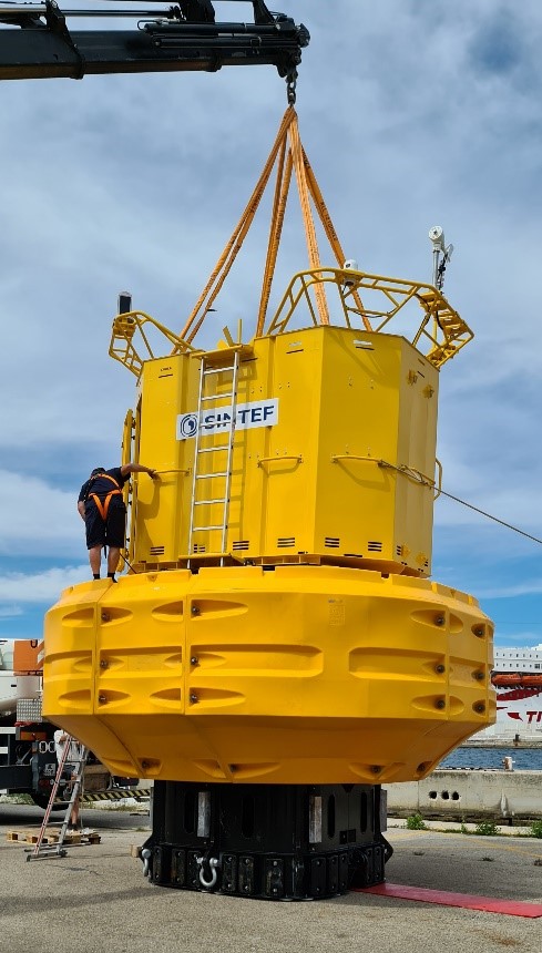
The other databuoy (DB24000) will be visible from the shore in Trondheim, as it will be placed just west of the Munkholmen island. To call this a ‘buoy’ is perhaps a little simplistic – in reality it will be more of a ‘floating lab’. Mobilis and Hydrosphere have worked closely with us in designing the structure specifically to accommodate the vast array of strange-shaped sensors that will be recording data here. The buoy has four ‘moon pools’ – holes in the bottom through which we can install sensors. One of these will contain a frame with lots of small sensors that can be automatically profiled up and down between the sea surface to the sea floor. Other instruments on this profiling frame will be taking microscopic images of plankton (SilCam & UVP-6) and measure their sizes (LISST-200x), along with the same environmental parameters being collected at the Ingdalen site. The second ‘moon pool’ is for an acoustic device (Signature-100) that measures the current speed and biomass under the buoy. The third ‘moon pool’ will house an in-situ imaging flow cytometer (CytoSub), which takes high magnification images of phytoplankton cells at the same time as measuring their fluorescence signals. Lastly, the fourth ‘moon pool’ is perhaps the most exciting, as this one is kept free and will be available for new ideas and experiments to use as they wish! New sensor concepts, biofouling reduction testing, and in-situ experiments, are only a few examples of the possibilities offered by this available space. But this is not just a ‘deployment hole’ – coupling to the power and data systems on the buoy, means that these experiments or tests can plug directly into the live data connection onshore using the 4G/5G network, at the same time as benefitting from all the other background environmental time-series data being collected.
Both buoys will be operational all year-round and will generate their own power from solar and wind. In the darkness of winter, backup methanol fuel cells will kick-in to give the batteries an extra top-up.
So, what is happening now? At SINTEF Ocean, we are preparing to receive shipment of the two buoys towards the end of August and will welcome a team of engineers from France and the UK to assemble these systems on the dockside next to NTNU’s vessel, RV Gunnerus. During the last week of August and first two weeks of September, we will work together onboard Gunnerus to set out the mooring lines and tow the buoys to their stations, where they will be collecting environmental data and supporting projects for the next 10 years. The system at Ingdalen will start collecting data almost immediately after deployment, while SINTEF will work over the following months to integrate the remaining sensors onto the Munkholmen site. Our goal is to have everything fully operational by November and thereon support as many users as possible to accelerate innovation and research that secures a sustainable future for the ocean.




Comments
Simply amazing, Emlyn & team. This must be the “Rolls-Royce” of ocean buoys 🙂 Looking forward the collaboration between C4IR Ocean, the Ocean Data Platform and Sintef.
Amazing Emlyn. Congratulations!
A giant step for mankind
Fantastic, Emlyn! Sounds like you’re having a great time! Congratulations!
Thanks Mark – great to hear from you!